 | |||||
 | |||||


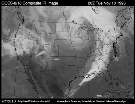
| Infrared Imagery - Estimating TemperatureIntroduction | Estimating Temperature | Cumulonimbus CloudsInfrared radiation (IR) is an invisible form of radiation given off by all objects both day and night. Satellites equipped with infrared sensors take pictures of clouds and of the Earth's surface. Infrared satellite measurements are related to temperature. In an infrared picture warmer objects appear darker than colder objects. Check out the example below (a composite of data from GOES-8 and GOES-10 satellites).
The troposphere is the level of the Earth's atmosphere where weather happens. Temperature in the troposphere decreases with height. That means high-level clouds are colder than low-level clouds. Therefore, low clouds (like those found over North Carolina and Virginia in the image above) appear darker, and higher clouds (like those found throughout the Eastern United States in the image) appear brighter. The very dark shades of gray in parts of the Rocky Mountains and in the deserts of the Southwest in the image are regions where the ground is being heated by the sun. Images and content from the University of Illinois WW2010 Project. | |||||||||||||||||||||||||||||||||
|
© 2005 by Wheeling Jesuit University/Center for Educational Technologies®. 316 Washington Ave., Wheeling, WV, 26003-6243. All rights reserved. Privacy Policy and Terms of Use. Some images copyright © 2004 www.clipart.com. |