Skip to NavigationSkip to Content
Image that reads Storm-E Weather Simulation that links to the Storm-E home page.
Button that takes you to Students.Button that takes you to Teachers.Button that takes you to Weather Extra.Button that takes you to Links.Button that takes you to Images.
Image that reads Weather Extra.
Weather Tools  
Time Zone  
Map Skills  
Glossary  
Radar Imagery  
Infrared Imagery  
Nor'easters  

Nor'easters

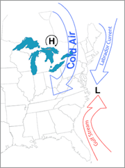
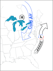
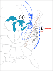
Nor'easters are storms that move north up the East Coast of the United States. Although they can occur at any time of the year, severe winter nor'easters are especially dangerous. Cold temperatures and high winds combine to produce unhealthy wind chills. Strong northeasterly winds that blow in off the ocean cause huge waves that crash onto Atlantic beaches. This often causes beach erosion and property damage. Heavy precipitation can accumulate very quickly in the form of rain, freezing rain, sleet, or snow.

A successful winter storm forecast should say what kind of precipitation (rain, freezing rain, or snow) will fall, when it will start, how long it will last, how hard it will be, and exactly where it will fall. This is especially hard for meteorologists when dealing with nor'easters, which are often unpredictable. So, what clues does a meteorologist look for when predicting a nor'easter?

Image of a nor'easter moving in on the United States.  This image links to a more detailed image.Nor'easters usually develop off the coast of North Carolina when the cold Labrador current and the warm Gulf Stream current meet. The contrast in the air temperatures above these currents help form a low pressure system. At the same time over Canada, winds circulate in a clockwise motion around a high pressure system. These winds dip deeply into the Northeastern United States bringing cold Canadian temperatures to support the formation of snow.

Image showing the movement of a nor'easter.  This image links to a more detailed image.The low begins to move north up the coast. At the same time, air rushes counterclockwise around it, bringing winds that blow from the Northeast toward the Southwest. These winds pick up moisture from the ocean. The movement of the winds and precipitation from the Northeast is why this storm is called a nor'easter. Picture a giant, wet Frisbee spinning counterclockwise as it flies north along the Atlantic Coast and you'll see the movement of a nor'easter.

Image showing the precipitation and movement of a nor'easter.  This image links to a more detailed image.Lift causes the moisture to rise and form clouds and precipitation. If the clouds are trapped east of the Appalachian Mountains, they drop precipitation on areas along the coast. A slow-moving storm system picks up more moisture and produces more precipitation than a fast-moving system.

So, are you ready to try your hand at meteorology? Go back to
your team area in the student section and learn more about how
to do your job. Good Luck.

For more information on nor'easters, check out:

Web Weather for Kids
http://www.ucar.edu/educ_outreach/webweather/index.html

USA Today Weather
http://www.usatoday.com/weather/tg/wnoreast/wnoreast.htm

Department of Atmospheric Sciences at the University of Illinois at Urbana-Champaign (for teachers)
http://severewx.atmos.uiuc.edu/index.10.html

http://severewx.atmos.uiuc.edu/index.10.noreaster.html


© 2005 by Wheeling Jesuit University/Center for Educational Technologies®. 316 Washington Ave., Wheeling, WV, 26003-6243. All rights reserved. Privacy Policy and Terms of Use.

Some images copyright © 2004 www.clipart.com.