|
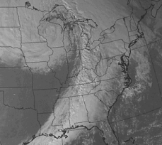
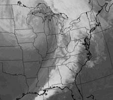
Visible and infrared are two types of satellite images. The
two images on this page show the same weather system.
These images are from the GOES satellite. GOES stands for
Geostationary Operational Environmental Satellites. It is a joint effort between
NASA and the National Oceanic and Atmospheric Administration (NOAA). GOES images
are seen every day on TV by millions of people.
Visible images (image a) measure the amount of solar
radiation the clouds reflect. Dark areas are where small amounts are reflected
back to space. Bright areas are places where large amounts are reflected back to
space.
Thick clouds reflect more light than thin clouds. They
appear brighter in a visible image. The example here shows a wide line of
clouds. These clouds stretch across the southeastern United States and then
northward into Ontario and Quebec.
|