 | |||||
 | |||||


| Radar ImageryIntroduction | Sending and Receiving Signals | Scattering of a Radar PulseRadar stands for "radio detection and ranging." Radar images help meteorologists find precipitation. Radar sends a pulse of energy into the atmosphere. If the pulse strikes precipitation, some of the energy is scattered back to the radar. These returned signals are called radar echoes. When a number of them are grouped, you get a radar image.
If you use only radar, you'll have trouble telling the difference between the various types of precipitation. Snow and light drizzle both have about the same value on the color scale. However, very high values (the grays on the scale) always mean hail. Image and content from the University of Illinois WW2010 Project. | |||||||||||||||||||||||||||||||||
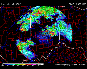 The radar image at right shows radar echoes over parts of Indiana, Ohio, and Illinois. The echoes point out where precipitation is falling. The colors indicate how strong the precipitation is. The color scale is in the lower left corner of the image. In this image several strong thunderstorms are moving through Illinois and Indiana on April 20, 1996. Light and dark blue regions indicate lighter precipitation. Red and pink regions show strong to occasionally severe thunderstorms.
 |
© 2005 by Wheeling Jesuit University/Center for Educational Technologies®. 316 Washington Ave., Wheeling, WV, 26003-6243. All rights reserved. Privacy Policy and Terms of Use. Some images copyright © 2004 www.clipart.com. |