 |
How
Hurricanes Work
A hurricane's bands don't play
marching music.
Circulating around the hurricane's eye are large, swirling bands
of wind, clouds, and driving rain. They circulate in bands causing
the rains to alternate between downpour and drizzle, often remaining
dangerously heavy long after the eye has passed. The winds,
on the other hand, are always strongest in those bands closest
to the hurricane's eye (alos called the "eyewall").
They decrease in strength the farther they are from the center.
Winds must be traveling at least 119 km per hour for the storm
to be classified a hurricane, but they can reach up to 250 km
an hour, or higher, depending on the strength of the storm.
| Hurricane winds are so strong
they have been known to lift a 180 kg. piece of lead and
move it more than 490 meters! These same winds drag across
the surface waters of the ocean, whipping them into a frenzy
of huge waves and tidal surges that eventually reach island
coastlines. |
 |
| In this
image of Hurricane Andrew, one can clearly make out the
eye, eyewall, and swirling rainbands. Image courtesy of
NOAA. |
Sailors suffered in the doldrums.
Doldrums: for humans, a period of listlessness or despondency
[probably akin to Old English "dol foolish" ] (1811).
For centuries the crews of sailing ships dreaded
sailing into a particular region of ocean near the Equator and
just off the western coast of Africa. The northeast and southwest
trade winds meet there, causing air to slowly rise. The rising
air produces only light winds and few ocean currents. Wind-powered
ships would become becalmed for days or weeks on end. The ship's
crews often became listless or despondent. Over time, this region
took on the name of this mental state – the Doldrums.
Ironically, some of the Caribbean's most violent
storms begin in the calm, warm waters of the Doldrums. This
deceptively tranquil region, southeast of the Cape Verde Islands,
has come to be known as the hurricane incubator. The waters
in this region may heat up to as high as 26º C, or higher.
Baby hurricanes grow out of heated ocean waters. In fact, hurricanes
cannot form in northern climates nor in winter months when the
ocean's waters cool.
Late in the season (which officially
starts June 1 and ends November 1), hurricanes in the Western
Hemisphere also form off the Yucatan Peninsula, in Central America,
and swirl around the Gulf of Mexico.
Why is low atmospheric pressure
such a big deal?
The lowest atmospheric pressure ever recorded at sea level was
an astounding 870 millibars, 143 millibars below normal. This
pressure was measured at the center of Typhoon Tip in the North
Pacific in 1979. Why is that astounding? Who cares about air
pressure measurements anyway?
To answer these questions, we must understand
a couple of ideas. Each particular location on Earth has a measurable,
atmospheric pressure. The pressure at that location is caused
by the weight of the column of air above that location. Typically,
meteorologists measure atmospheric pressure using a mercury
barometer. The weight of the air above the Earth is equal to
the weight of the column of mercury in the barometer. This column's
height can be precisely measured. Standard, sea-level atmospheric
pressure is 1013 millibars. This amount of air pressure supports
a column of mercury 76 cm. high. Air pressure decreases as we
rise above the Earth because there is less air above us the
higher up we go. But atmospheric pressures can change at the
surface of the Earth as well. They go up and down by small amounts
and cause the "highs" and "lows" you hear
about on weather reports.
Under normal conditions and over a normal
period of time, the atmospheric pressure usually changes no
more than 20 millibars. The mercury in the barometer usually
rises or falls only a little bit in a period of 12 to 24 hours.
But even small differences in atmospheric pressure cause the
air to be pushed around. This air movement is called wind. In
this way air pressure and wind are closely related. Wind moves
out of areas of high air pressure and sweeps into areas of low
air pressure. The greater the difference in air pressure from
one place on Earth to another, the stronger the wind.
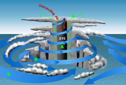
Use the illustration above to understand this
phenomenon. The atmospheric pressure in the eyes (A) of hurricanes
and typhoons is lower than in the surrounding atmosphere, so
air spirals inward in the form of strong surface winds (B).
If the center of low pressure is over warm ocean waters, the
spiraling winds whip up waves and froth. This adds to the already
high levels of water evaporation. The warm, wet air spirals
in toward the center of the storm and then cools as it rises
(C). The water vapor the air is carrying condenses and forms
clouds and rain (grey areas in the illustration). As the condensation
evaporates, it again heats the rising air, causing the air to
rise upward even faster. The expanding air rises to altitudes
of 10 to 15 km. Then, as the air cools, it flows outward over
the top of the storm. This cool air flow outwards, lowers the
weight of the air above the storm's center even more. The winds
increase and draw in more wet air. As long as the hurricane
is over warm water, this cycle continues and tends to get stronger.
The pressure in the storm's center gets lower and lower, and
the winds blow faster and faster.
The strongest winds in a hurricane are in
the eyewall. Typhoon Tip's very low atmospheric pressure reading
of 870 millibars created catastrophically high winds that swirled
in bands around its eye. Typhoon Tip not only had the lowest
atmospheric pressure on record, but also 320 km per hour winds—winds
moving as fast as a racing car qualifying for the 2003 Indianapolis
500!
The birth of a storm is not a
time for celebration.
Pushed by the trade winds, low pressure systems that form off
Africa's coast begin to head west across the Atlantic. As they
travel they might die out, or they might gain speed depending
on weather conditions in the region. When winds reach 62 km
per hour and stay at that speed for at least one minute, meteorologists
call the phenomenon a system and call the system a tropical
storm. Satellite photographs of the region will begin to record
the formation of a central eye and spiraling bands of clouds.
While meteorologists marvel at the beautiful symmetry of the
formation, they also begin to estimate its growing dangers.
Caribbean islanders become very nervous. To them, a hurricane
in the Atlantic is like a giant game of chance. Where will it
land? Whose home will be spared? Whose will be destroyed?
Order out of chaos
When a weather system's winds reach 119 km per hour, the storm
is formally called a hurricane. Meteorologists give the hurricane
a name. The name makes it easier for islanders to distinguish
from other possible hurricanes in the region. It also warns
everyone that a storm can be as unpredictable as a person. The
scientists monitor the changes in the storm's strength, the
direction in which it is traveling, and other weather formations
in the area. They classify the storm using five major categories
(see next page). To track
its direction and possible landfall, scientists compare the
storm's changing longitudinal and latitudinal position with
the paths of previous storms.
Over the centuries hurricanes have followed
certain paths, heading west and veering toward the north as
they reach the Caribbean. But meteorologists must also look
at other factors that influence a storm's direction —
time of year, ocean temperature, other storms in the region.
Any storm system may surprise even the most seasoned meteorologist
by wobbling, looping, turning back, or even stalling in its
tracks!

Review Questions
- Where are the strongest winds of a hurricane? Where are
the weakest winds?
- What factors do meteorologists examine when predicting the
path of a hurricane?
- Describe what happens to the atmospheric pressure in a hurricane.
|
 |