Teacher
Introduction
In the Target Moon mission students
locate bases using latitude and
longitude as reference points. Plotting
the possible points of impact will
require students to accurately predict
the path of the comet and determine the
areas of ejecta at each location in
order to move the astronauts to safety.
A good understanding of
latitude and longitude is essential to the
Target Moon mission. This lesson reviews
information usually covered in a social studies
class but embeds it in a space science scenario
with an approach that integrates it with science
and math.
Duration
60 minutes
Materials
Vocabulary
equator: a
circle of the Earth or celestial body that
is equally distant from the two poles and
divides the surface into northern and
southern hemispheres.
latitude: the
distance north or south of the equator.
longitude: the
distance east or west of the prime meridian.
prime meridian:
the meridian of 0 degrees longitude which
runs through the original site of the Royal
Observatory at Greenwich, England, and which
forms the reference point for lines of
longitude east and west.
Latitude and Longitude
Review
Latitude is the distance north or south of
the equator; imaginary lines measured in terms
of 360 degrees of a circle help us locate points
or locations on a sphere like Earth or the Moon.
The equator is the line of 0
degrees latitude. Lines of latitude start from
the equator and go north to the North Pole and
south to the South Pole. The North Pole is
labeled 90 degrees north latitude and the South
Pole is 90 degrees south latitude. The latitude
of every point in between must be some degree
north or south from 0 to 90 degrees. One degree
of latitude covers about 69 miles, or 111
kilometers.
These lines are called
parallels of latitude because they run parallel
to the equator.
Longitude
Longitude is the distance east or west of
the prime meridian; imaginary lines measured in
terms of 360 degrees of a circle help us locate
points or locations on a sphere like Earth or
the Moon.
Longitude is measured the
same way as latitude except that the lines run
east and west. Lines of longitude are called
meridians and just as latitude must have a
starting reference line. Longitude lines begin
at 0 degrees at the line that runs through
Greenwich, England. This line is internationally
accepted as the 0 degree longitude and is known
as the prime meridian.
For even greater accuracy
degrees of latitude and longitude are further
divided into 60 minutes, and minutes are divided
into 60 seconds. Students will not have to
measure in minutes or seconds for their Target
Moon mission.
Finding Locations
When you use a map to locate a position, you
often use the degrees of latitude and longitude.
These are called coordinates. If you know the
coordinates of a point, you can use a map marked
off in latitude and longitude to locate any
point on the sphere.
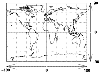
Image:
http://jwocky.gsfc.nasa.gov/teacher/latlon.html
To identify locations with
their coordinates (latitude and longitude) or to
find locations using latitude and longitude, you
must know how the lines are defined. Latitude is
measured from the equator with positive values
going north and negative values going south.
Longitude lines are measured
from the prime meridian with positive values
going east and negative values going west.
Example: Find the
latitude and longitude for Washington, DC.
Find the latitude by
locating Washington and the two closest latitude
lines. In this case it will be the 40 degree
latitude line and the 35 degree latitude line.
Washington is south of the 40 degree line but
north of the 35 degree line. By estimating how
far Washington is from each line, you can see
that Washington is approximately 38 degrees
north latitude.
Find the longitude by
finding the two longitude lines closest to
Washington. The city lies between the 75 degree
and 80 degree west longitudes. By estimating,
you can see that Washington’s longitude location
is approximately 77 degrees west.
Procedure
-
Read the information
about latitude and longitude with the
students in class.
-
Encourage discussion and
ask questions to check for understanding of
the material.
-
Review the Target Moon
scenario and make sure the students relate
the material they learn in this lesson with
their work in the mission.
-
Work the example for
Washington, DC, with the students.
-
Have the students
practice identifying locations by finding
latitudes and longitudes. You can use a map
from the appendix of a social studies or
science textbook if you do not have world
maps for the students to use.
-
Check for understanding.
Locations to find:
-
A city you would like to
visit.
-
The city in which you
were born.
-
The city in which a
parent was born.
-
Where you would like to
vacation.
-
Where you would like to
live one day.
-
Where your favorite
sports team is located.
-
The farthest place you
have visited compared to where you live now.
|