Skip to NavigationSkip to Content
Image that reads Storm-E Weather Simulation that links to the Storm-E home page.
Button that takes you to Students.Button that takes you to Teachers.Button that takes you to Weather Extra.Button that takes you to Links.Button that takes you to Images.
Image that reads Weather Extra.
Weather Tools  
Time Zone  
Map Skills  
Glossary  
Radar Imagery  
Infrared Imagery  
Nor'easters  

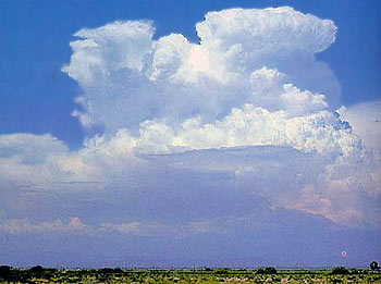
Infrared Imagery - Cumulonimbus Clouds

Introduction | Estimating Temperature | Cumulonimbus Clouds

Cumulonimbus clouds (Cb) are much larger and taller than fair weather cumulus. They can exist as individual towers or form a line of towers called a squall line. The tops of cumulonimbus clouds can easily reach 39,000 feet (12,000 meters) or higher.

Image of cumulonimbus clouds.
Image courtesy NASA/JPL
Under favorable atmospheric conditions, harmless fair weather cumulus clouds can quickly develop into large cumulonimbus clouds associated with powerful thunderstorms known as supercells.

Content from the University of Illinois WW2010 Project.

Privacy Statement and Copyright © 1999-2004 by Wheeling Jesuit University/The NASA-sponsored Classroom of the Future program. All rights reserved.
Some images copyright © 2004 www.clipart.com.