|  | Map SkillsCompass Rose  Maps often have a symbol like this to show directions north, south, east, and west. This is called a compass rose because the points on the symbol look like the petals of a flower. Maps often have a symbol like this to show directions north, south, east, and west. This is called a compass rose because the points on the symbol look like the petals of a flower.
Map Scales 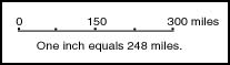 Maps cannot be the same size as the actual area they show because obviously the maps would be too big. Mapmakers, who are called cartographers, create a relationship between the real size and the map size that is shown on a scale. For example, one inch on a map might equal one mile on a road. Maps cannot be the same size as the actual area they show because obviously the maps would be too big. Mapmakers, who are called cartographers, create a relationship between the real size and the map size that is shown on a scale. For example, one inch on a map might equal one mile on a road.
Math Symbols Symbols rather than words are often used to shorten and simplify equations. Here are examples of some symbols: | Symbol | Meaning | Example |
|---|
| > | Greater than | 10 > 2 | | < | Less than | 2 < 10 | | > | Greater than or equal to | 10 > 10, 9, 8. . . | | < | Less than or equal to | 2 < 2, 3, 4. . . |
|