Skip to NavigationSkip to Content
Image that reads Storm-E Weather Simulation that links to the Storm-E home page.
Button that takes you to Students.Button that takes you to Teachers.Button that takes you to Weather Extra.Button that takes you to Links.Button that takes you to Images.
Image that reads Weather Extra.
Weather Tools  
Time Zone  
Map Skills  
Glossary  
Radar Imagery  
Infrared Imagery  
Nor'easters  

Radar Imagery - Scattering of a Radar Pulse

Introduction | Sending and Receiving Signals | Scattering of a Radar Pulse

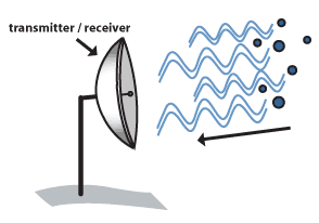
When the electromagnetic pulse encounters a target (image a), the pulse is scattered in all directions (image b). The signal received is much weaker than the original sent from the transmitter. This is called the return signal (image c).

Several factors affect how strong the return signal is. The larger the target, the stronger the return signal. For example, if a radar pulse encounters a large piece of hail, it will send back a stronger signal than if it struck a small raindrop.

Also, the more targets there are to scatter the pulse, the stronger the return will be. That's because the return signals from each target combine to produce a stronger signal. This means that many raindrops will produce a stronger return than a few raindrops.

Image of radar encountering a target.
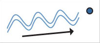
  (a) Radar encountering a target.

Image of scattering of a radar pulse.
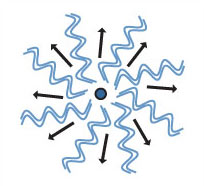
  (b) Target scattering radar.

Image of radar receiving pulse.
  (c) Radar receiving return.

Meteorologists use the term "reflectivity" to describe the strength of the return signal. They use a color scale to measure reflectivity. Heavy precipitation produces a strong return signal. It would be indicated by a color at the high end of the reflectivity scale. Light precipitation produces a weak return signal. It would be indicated by a color at the low end of the reflectivity scale.

Content from the University of Illinois WW2010 Project.

Privacy Statement and Copyright © 1999-2004 by Wheeling Jesuit University/The NASA-sponsored Classroom of the Future program. All rights reserved.
Some images copyright © 2004 www.clipart.com.