 | |||||
|
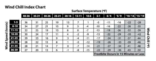
Wind Chill IndexWhy worry about the wind chill index? Bitter cold weather can be dangerous. Frostbite and hypothermia can develop if you don’t wear proper clothing or take precautions. Frostbite may injure skin tissue exposed to intense cold. Hypothermia is when the internal body temperature drops low enough that muscles and the brain do not work properly. The wind chill index estimates how cold it feels based on a combination of actual temperature and wind speed. To use the chart below, first put your finger on a temperature reading at the top of the chart. Next put another finger on the wind speed reading along the left-hand column. Run your fingers down and across the chart until your fingers meet. This is the wind chill temperature. For example, a surface temperature of 23 degrees Fahrenheit and a wind speed of 30 knots will result in a wind chill reading of 8 degrees Fahrenheit.
| |||||||||||||||||||||||||||||||||
Privacy Statement
and Copyright © 1999-2004
by Wheeling Jesuit University/The NASA-sponsored Classroom of the Future program. All
rights reserved. |